 JG Afrika recently completed hydrological, topographical, sedimentation and climate studies to assist the Malawian government rebuild railway infrastructure in an area of the country that is prone to devastating floods.
The railway line extends from the Mozambican border in the south of Malawi, to Bangula, at the confluence of the Shire and the Ruo Rivers. Here, it crosses extensive floodplain areas, before travelling adjacent to the Ruo River to Sandama and onwards to the Limbe Station in Blantyre.
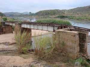
Railway wash aways
Simon Johnson, a Technical Director at JG Afrika, says the study focused on the section of the line where significant flooding occurred in January 2015 as a result of cyclonic activity, particularly in the vicinity of the Ruo River from Sandama to its confluence with the Shire River, at Makhanga and the Chiromo crossing of the Shire River to Bangula.
“Floods caused massive erosion and wash away damage on several sections of the railway line that are close to the river. Several bridges, including the Chiromo crossing across the Shire River, also washed away. The infrastructure is important from a national and a local perspective as it acts as a link to the Mozambican port of Beira. This is in addition to providing the communities living adjacent to the line with a means of moving agricultural produce and trading in neighbouring villages and even in main centres such as Blantyre,” Johnson says.
Makhanga community
 During high flow events from the Ruo River, the Makhanga community suffers from large scale flood damage and subsequent loss of life. During January 2015, the Ruo River changed its course as a result of large sediment deposition that blocked the historical flow path. The river moved in a south easterly direction around Makhanga and this opened a new channel that flowed in a westerly direction to the north of the village. The river channel is a defined boundary between Malawi and Mozambique and this, therefore, created significant socio-political problems in the area.
Before January 2015, the Malawian government was undertaking preliminary design of upgrades to the railway infrastructure in this area. Considering the extent of the damage caused by the floods, it decided to first appoint specialists to undertake hydrological, topographical, sedimentation and climate studies to better inform the repairs.
International funding
 The government received financing from the International Development Association toward the cost of the Malawi Floods Emergency Recovery Project (MFERP). Through the MFERP Project Implementation Unit, the government appointed a Joint Venture between JG Afrika and Royal HaskoningDHV (RHDHV) in association with a local Malawian company, Majiatua Engineering Services, to undertake the study.
We were responsible for most of the outputs and were supported by RHDHV on the sedimentation studies. MESI Consulting provided important in-country support, as well as hydrological input and context of the working environment. Survey support services were provided by Southern Mapping and Surveys Malawi.
Outcomes of the study were workshopped with a variety of different local and national stakeholders. Notably, our work, including simulated flood levels, was accepted by the authorities shortly before Cyclone Idai made landfall in March 2019. The extent of the flooding mirrored the simulations generated during the study and acted as a further validation of its outputs.